
CHASE BLOGS

USA STORM CHASE 2013
MAY 31 2013
Today was one of the toughest, most devastating, dramatic and humbling chase days that I have encountered in my 11 years of storm chasing.
All the ingredients were there for a severe weather outbreak today in Oklahoma. With High CAPE values the SPC had issued a moderate risk for today, my only surprise was that it wasn't elevated to a high risk as the new forecasts were issued during the day.
We targeted the area around El Reno, and initiation of the first storms was fast, but instead of individual storms firing up, a cluster of embedded Supercells formed, each with its own mesocyclone which appeared behave very erratically. This had the making of a very complicated and dangerous chase.
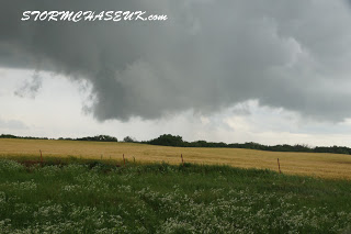
We saw a multi vortex tornado touch down on several occasions in a field near the airport, but then as we travelled east along I-40 we witnessed a massive wedge tornado, that was wrapped in heavy precipitation. We were first alerted to it by huge power flashes on both sides of the Interstate as it became visible as it crossed in front of us to our south. We were relatively safe at this point as it was moving SE, but this tornado was close and so big it was too large to fit in the frame of the video camera. I managed to get a still photo (see below) that just captured the entire funnel as it came out of the rain.
The tornado took a sharp turn to the north right towards us and we had to quickly get off the interstate and try to find an east route for a south road out of its path. This was made difficult by downed trees and power lines blocking most exit roads, and all this combined with heavy traffic and erratic drivers made finding safety all the more difficult.
We eventually managed to get south away from the massive storm system that had now been chasing us!, and spent the night south of the metro area in the town of Lawton, All routes back north had been closed by authorities due to the severe weather conditions.
It has been confirmed however that well known storm chaser Tim Samaras, his son Paul and Twistex companion Carl Young were tragically killed in the El Reno tornado. This is a sad and huge loss to the science and storm chasing communities. These were people that I met once and hugely respected for what that had accomplished in the field of science for tornado genesis.
The El Reno tornado has been classified as the largest tornado ever documented. It was categorised as an EF-5 with a diameter of 2.6 miles with wind speeds of 476km/hr /296mph.
Today really has bought home how powerful nature really is, and how dangerous storm chasing can be.

MAY 30 2013
Another chase day with bags of potential that never really came together. Once again it was another moderate risk day. The storms that fired around the Guthrie area quickly became tornado warned once again, but just as before never really became organised.
They would continually reorganise whilst we relocated around them. And that really was the story of the day. The real surprise though was that they fired just after midday and grew quickly. They soon became embedded and linear just as fast and the days chase was realistically over by 5pm. That was a first for this chase trip!
Tomorrow has even more strong potential. This looks likely to be our last chase of the trip as Saturdays set up looked to be too far east to chase. Lets hope this one works out
MAY 29 2013
Another chase day with a lot of potential. A moderate risk was once again issued by the Storm Prediction Center for severe weather within out region.
We positioned ourselves in North Western Oklahoma and waited for the storms to fire up, However when they did they began to become an embedded line of storms rather than discreet Supercells that would be better for tornado genesis. There was rotation on some cells which quickly became tornado warned, but the rotation did not tighten sufficiently for the formation of a tornado to become possible.
As we kept in front of one of the storms, it produced a very photogenic shelf cloud which eventually was overtaken by the outflow.
Once this had occurred the potential for the day was pretty much over so we decided to relocate to Enid, OK for tomorrows chase.

MAY 28 2013
Wow what an awesome chase day!. It just goes to show that even if the potential is not as good as yesterdays moderate risk, this slight risk day can deliver better storms.
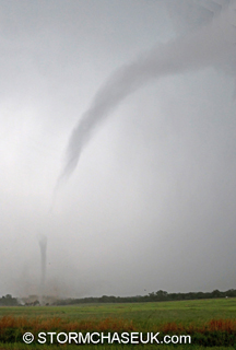
It was tough to pick a target area, as there was potential in over 450,000 miles of chase terrain in over 4 States. However we managed to do it as we got on a isolated cell that fired up just outside the town of Bennington, KS.It was almost stationary and we watched as it got a very pronounced hook on radar and after seeing rotation visibly it began to drop a tornado which quickly became more intense and grew into a huge wedge tornado.
We repositioned ourselves to our SW so that we stayed close to it. So close in fact we could hear the roar as it churned through the landscape.
It eventually became embedded in rain and visibly difficult to track as the storm became HP, so we decided to call the chase and keep away from the strong core of the storm.
We decided to relocate to Salina, KS and enjoy a well deserved steak dinner,


MAY 27 2013
Hopes were high today for a successful chase, but that was not the case despite the moderate risk issued by the SPC and the relatively small target area. All the ingredients were there including decent CAPE values, but the storms just did not get sufficiently organised.
We headed to a storm just outside Lucas, KS that produced some nice structure and became severe warned but began to die before becoming fully organised.
Overall it was a disappointing day after having such high expectations...but that's storm chasing for you.
We eventually relocated in Hays, KS ready for tomorrows chase.
MAY 26 2013
Storms were due to initiate later in the day, so we took some time this morning visiting Mount Rushmore in South Dakota.
We eventually got onto a storm as it fired around the Wyoming, Nebraska border but it was struggling to get organised.
The one cell that fired and had a great structure was in SE Nebraska which was too far out of our reach.
We eventually decided to relocate to Ogallalla Kansas, to put us in good position for tomorrows chase potential.

MAY 25 2013
It was apparent that todays target was going to be further north into Nebraska, but that's not how things turned out as we finally intercepted a storm in Rapid City, South Dakota!
We headed out from Corby, KS, Storm initiation was not expected to be too early so we knew we had ample time to intercept storms as they fired up.
As we drove trough Nebraska we could see a storm building to our north that looked great on radar and was almost stationary. We headed for that expecting it to dissipate before we got to it, but it didn't!.
As we intercepted it outside the town of Rapid City. However it again was high based but was very strong. We drove through some small hail as we core punched it, however the stones got harder and bigger! Our vehicles took some big hits and our windscreen was badly cracked, as we John's who was behind us.
Around sunset we viewed the structure and in was really beautiful, one of the best that I have seen in my time chasing storms.
We eventually relocated to Rapid City, SD for the night.


MAY 24 2013
Today we had some relatively good storm potential but in meant heading north quickly into Kansas to get into position.
Storm initiation was not too early so we were able to intercept the cells as they fired up around the town of Goodland.
The best storm quickly became severe warned as we intercepted it and experienced golf
ball sized hail in it's core. The problem was it was very high based due to a lack of moisture, which is why it did not become tornado warned.
As the sun began to set we witnessed it's really picturesque LP (low precipitation) supercell structure.


MAY 23 2013
Today was forecast as a moderate risk for severe weather and we were all hoping for a little Pan Handle magic as we headed out of south out of Childress for the days chase.
Sure enough as we targeting the area around the town of Floydata a cell fired up and soon became tornado warned. It was looking good on radar for a while but was still visually struggling to get organised with a core which contained hail of monstrous proportions. The main problem was the lack of moisture and all the red dust that was flying around in the dry landscape, It made the storm very difficult to view visually.
A few tornado reports came in but we soon realised it was the red dust being pulled vertically into the inflow. To the untrained eye it would have looked like a tornado, but there was definitely no rotation involved.
We had a fun intercept as we were hit by an intense gust front as we watched by the storms outflow boundary, before relocating to the town of Rotan as the tornado warning diminished from the storm.
As we were there we decided to take shelter as the core was about to hit us. We encountered some small hail but really heavy rain and straight line winds in excess of 60mph.
We decided to call off the storm when it had passed and put in some miles to get to Amarillo for the night which would put us in good position for tomorrows chase.


MAY 22 2013
Today was a relocation day to get into position to chase tomorrows potential, We took our time in heading from Waco, Texas to Childress.
This travel day gave all of us chance to talk and share stories about our lost friend Chris. It was some time I think we all needed.
MAY 21 2013
Today was a terrible day for us, as we had to say goodbye to our chaser friend Chris Curtis. He passed away this morning in the hotel room next to me of a heart attack.
We are all in a state of shock, Ian and I had chased storms with him for the last 10 years, he was a great guy, a true gent and a dedicated storm chaser.
We didn't fell much like chasing todays risk areas to the south, especially as we were expecting the storms to initiate early and become very linear very quickly. However the SPC had issued a moderate risk for that area, and we decided as a group that we would continue on, as we believed that's what Chris would have wanted us to do, and we would like to intercept some good storms before we leave in his honour.
As expected the storms lined out and became a huge MCS mess, as they just got undercut by outflow and died very quickly. We chased until the light faded before relocating in Waco, TX for the night.
MAY 20 2013
Today was the worst day that I have experienced since I have been chasing storms.
Moore Oklahoma was hit by a 2 mile wide EF-4 rated tornado that tore a path of destruction through the State.
As I write this many people have been killed, I don't know the exact number, including children missing presumed dead when the tornado hit their school in Moore.
We enjoy chasing storms, they are exhilarating to experience, but we always hope that they hit open unpopulated areas and do not affect or take peoples lives. but unfortunately sometimes they do.
Our thoughts and prayers are with those people lost and for their families as they now try to rebuild their lives.
We were not witness to that destruction yesterday, We chased further south in the State.
I am not sure I would have wanted to see that storm, but had I been there I would have like to have helped in any way possible.

MAY 19 2013
Today was a moderate risk with a 15% hatch risk for tornadoes. We decided to head north out of Norman OK to play the storms in southern Kansas that were due to initiate early in the day.
Sure enough a storm fired up and began to organise very quickly, it developed a radar hook and showed visible rotation. Soon after a funnel dropped and there was a visible dust swirl on the ground which lasted a couple of minutes near the town of Viola.
As we followed the cell further north a brief photogenic elephant trunk briefly touched down very close to our location. Further storms began to form just to the south of ours but soon began to merge and became very linear.
We decided to abandon the storm and head for the ones that then began to fire back in the OKC vicinity. As were headed south one organised very quickly and produce a hook on radar and radio reports confirmed that a large tornado was visible and was heading towards the town of Shawnee. Reports came in later of damage and 2 unfortunate fatalities. We intercepted the storm as it began to dissipate and decided to spend the night there in order to put us in position for the chase tomorrow.

MAY 18 2013
We arrived in OKC about 11pm Central time so that's 5am in the UK after a long and interesting flight to Tornado Alley,
Our flight from Heathrow was delayed and there was no in flight entertainment so the flight crew decided to let us entertain ourselves by compensating all passengers by making all beer and wine on the flight complimentary!. This needless to say meant that it all ran out about halfway though the flight and the passengers were very mellow.
We connected in Atlanta for the onward flight, however when we were arriving in Oklahoma City we were forced to circle about 50 miles from the airport due to a storm whilst waiting for a window to land. One came and we were forced to skirt around 2 cells, this was where the fun began.
As we flew past the clouds which were all electrified our plane was struck by lightning, and we saw St Elmo's fire outside the window. We landed safely enough though to the relief of many nervous passengers.
Tomorrow our chase starts as the active weather pattern continues..

MAY 17 2013
The final preps are being made for the chase trip that starts tomorrow. The outlook is for an active pattern so there looks to be good storm chasing potential for the next few days at least.
Please visit the blog for the next two weeks for regular updates.
Today was one of the toughest, most devastating, dramatic and humbling chase days that I have encountered in my 11 years of storm chasing.
All the ingredients were there for a severe weather outbreak today in Oklahoma. With High CAPE values the SPC had issued a moderate risk for today, my only surprise was that it wasn't elevated to a high risk as the new forecasts were issued during the day.
We targeted the area around El Reno, and initiation of the first storms was fast, but instead of individual storms firing up, a cluster of embedded Supercells formed, each with its own mesocyclone which appeared behave very erratically. This had the making of a very complicated and dangerous chase.
We saw a multi vortex tornado touch down on several occasions in a field near the airport, but then as we travelled east along I-40 we witnessed a massive wedge tornado, that was wrapped in heavy precipitation. We were first alerted to it by huge power flashes on both sides of the Interstate as it became visible as it crossed in front of us to our south. We were relatively safe at this point as it was moving SE, but this tornado was close and so big it was too large to fit in the frame of the video camera. I managed to get a still photo (see below) that just captured the entire funnel as it came out of the rain.
The tornado took a sharp turn to the north right towards us and we had to quickly get off the interstate and try to find an east route for a south road out of its path. This was made difficult by downed trees and power lines blocking most exit roads, and all this combined with heavy traffic and erratic drivers made finding safety all the more difficult.
We eventually managed to get south away from the massive storm system that had now been chasing us!, and spent the night south of the metro area in the town of Lawton, All routes back north had been closed by authorities due to the severe weather conditions.
It has been confirmed however that well known storm chaser Tim Samaras, his son Paul and Twistex companion Carl Young were tragically killed in the El Reno tornado. This is a sad and huge loss to the science and storm chasing communities. These were people that I met once and hugely respected for what that had accomplished in the field of science for tornado genesis.
The El Reno tornado has been classified as the largest tornado ever documented. It was categorised as an EF-5 with a diameter of 2.6 miles with wind speeds of 476km/hr /296mph.
Today really has bought home how powerful nature really is, and how dangerous storm chasing can be.
MAY 30 2013
Another chase day with bags of potential that never really came together. Once again it was another moderate risk day. The storms that fired around the Guthrie area quickly became tornado warned once again, but just as before never really became organised.
They would continually reorganise whilst we relocated around them. And that really was the story of the day. The real surprise though was that they fired just after midday and grew quickly. They soon became embedded and linear just as fast and the days chase was realistically over by 5pm. That was a first for this chase trip!
Tomorrow has even more strong potential. This looks likely to be our last chase of the trip as Saturdays set up looked to be too far east to chase. Lets hope this one works out
MAY 29 2013
Another chase day with a lot of potential. A moderate risk was once again issued by the Storm Prediction Center for severe weather within out region.
We positioned ourselves in North Western Oklahoma and waited for the storms to fire up, However when they did they began to become an embedded line of storms rather than discreet Supercells that would be better for tornado genesis. There was rotation on some cells which quickly became tornado warned, but the rotation did not tighten sufficiently for the formation of a tornado to become possible.
As we kept in front of one of the storms, it produced a very photogenic shelf cloud which eventually was overtaken by the outflow.
Once this had occurred the potential for the day was pretty much over so we decided to relocate to Enid, OK for tomorrows chase.
MAY 28 2013
Wow what an awesome chase day!. It just goes to show that even if the potential is not as good as yesterdays moderate risk, this slight risk day can deliver better storms.
It was tough to pick a target area, as there was potential in over 450,000 miles of chase terrain in over 4 States. However we managed to do it as we got on a isolated cell that fired up just outside the town of Bennington, KS.It was almost stationary and we watched as it got a very pronounced hook on radar and after seeing rotation visibly it began to drop a tornado which quickly became more intense and grew into a huge wedge tornado.
We repositioned ourselves to our SW so that we stayed close to it. So close in fact we could hear the roar as it churned through the landscape.
It eventually became embedded in rain and visibly difficult to track as the storm became HP, so we decided to call the chase and keep away from the strong core of the storm.
We decided to relocate to Salina, KS and enjoy a well deserved steak dinner,
MAY 27 2013
Hopes were high today for a successful chase, but that was not the case despite the moderate risk issued by the SPC and the relatively small target area. All the ingredients were there including decent CAPE values, but the storms just did not get sufficiently organised.
We headed to a storm just outside Lucas, KS that produced some nice structure and became severe warned but began to die before becoming fully organised.
Overall it was a disappointing day after having such high expectations...but that's storm chasing for you.
We eventually relocated in Hays, KS ready for tomorrows chase.
MAY 26 2013
Storms were due to initiate later in the day, so we took some time this morning visiting Mount Rushmore in South Dakota.
We eventually got onto a storm as it fired around the Wyoming, Nebraska border but it was struggling to get organised.
The one cell that fired and had a great structure was in SE Nebraska which was too far out of our reach.
We eventually decided to relocate to Ogallalla Kansas, to put us in good position for tomorrows chase potential.
MAY 25 2013
It was apparent that todays target was going to be further north into Nebraska, but that's not how things turned out as we finally intercepted a storm in Rapid City, South Dakota!
We headed out from Corby, KS, Storm initiation was not expected to be too early so we knew we had ample time to intercept storms as they fired up.
As we drove trough Nebraska we could see a storm building to our north that looked great on radar and was almost stationary. We headed for that expecting it to dissipate before we got to it, but it didn't!.
As we intercepted it outside the town of Rapid City. However it again was high based but was very strong. We drove through some small hail as we core punched it, however the stones got harder and bigger! Our vehicles took some big hits and our windscreen was badly cracked, as we John's who was behind us.
Around sunset we viewed the structure and in was really beautiful, one of the best that I have seen in my time chasing storms.
We eventually relocated to Rapid City, SD for the night.
MAY 24 2013
Today we had some relatively good storm potential but in meant heading north quickly into Kansas to get into position.
Storm initiation was not too early so we were able to intercept the cells as they fired up around the town of Goodland.
The best storm quickly became severe warned as we intercepted it and experienced golf
ball sized hail in it's core. The problem was it was very high based due to a lack of moisture, which is why it did not become tornado warned.
As the sun began to set we witnessed it's really picturesque LP (low precipitation) supercell structure.
MAY 23 2013
Today was forecast as a moderate risk for severe weather and we were all hoping for a little Pan Handle magic as we headed out of south out of Childress for the days chase.
Sure enough as we targeting the area around the town of Floydata a cell fired up and soon became tornado warned. It was looking good on radar for a while but was still visually struggling to get organised with a core which contained hail of monstrous proportions. The main problem was the lack of moisture and all the red dust that was flying around in the dry landscape, It made the storm very difficult to view visually.
A few tornado reports came in but we soon realised it was the red dust being pulled vertically into the inflow. To the untrained eye it would have looked like a tornado, but there was definitely no rotation involved.
We had a fun intercept as we were hit by an intense gust front as we watched by the storms outflow boundary, before relocating to the town of Rotan as the tornado warning diminished from the storm.
As we were there we decided to take shelter as the core was about to hit us. We encountered some small hail but really heavy rain and straight line winds in excess of 60mph.
We decided to call off the storm when it had passed and put in some miles to get to Amarillo for the night which would put us in good position for tomorrows chase.
MAY 22 2013
Today was a relocation day to get into position to chase tomorrows potential, We took our time in heading from Waco, Texas to Childress.
This travel day gave all of us chance to talk and share stories about our lost friend Chris. It was some time I think we all needed.
MAY 21 2013
Today was a terrible day for us, as we had to say goodbye to our chaser friend Chris Curtis. He passed away this morning in the hotel room next to me of a heart attack.
We are all in a state of shock, Ian and I had chased storms with him for the last 10 years, he was a great guy, a true gent and a dedicated storm chaser.
We didn't fell much like chasing todays risk areas to the south, especially as we were expecting the storms to initiate early and become very linear very quickly. However the SPC had issued a moderate risk for that area, and we decided as a group that we would continue on, as we believed that's what Chris would have wanted us to do, and we would like to intercept some good storms before we leave in his honour.
As expected the storms lined out and became a huge MCS mess, as they just got undercut by outflow and died very quickly. We chased until the light faded before relocating in Waco, TX for the night.
MAY 20 2013
Today was the worst day that I have experienced since I have been chasing storms.
Moore Oklahoma was hit by a 2 mile wide EF-4 rated tornado that tore a path of destruction through the State.
As I write this many people have been killed, I don't know the exact number, including children missing presumed dead when the tornado hit their school in Moore.
We enjoy chasing storms, they are exhilarating to experience, but we always hope that they hit open unpopulated areas and do not affect or take peoples lives. but unfortunately sometimes they do.
Our thoughts and prayers are with those people lost and for their families as they now try to rebuild their lives.
We were not witness to that destruction yesterday, We chased further south in the State.
I am not sure I would have wanted to see that storm, but had I been there I would have like to have helped in any way possible.
MAY 19 2013
Today was a moderate risk with a 15% hatch risk for tornadoes. We decided to head north out of Norman OK to play the storms in southern Kansas that were due to initiate early in the day.
Sure enough a storm fired up and began to organise very quickly, it developed a radar hook and showed visible rotation. Soon after a funnel dropped and there was a visible dust swirl on the ground which lasted a couple of minutes near the town of Viola.
As we followed the cell further north a brief photogenic elephant trunk briefly touched down very close to our location. Further storms began to form just to the south of ours but soon began to merge and became very linear.
We decided to abandon the storm and head for the ones that then began to fire back in the OKC vicinity. As were headed south one organised very quickly and produce a hook on radar and radio reports confirmed that a large tornado was visible and was heading towards the town of Shawnee. Reports came in later of damage and 2 unfortunate fatalities. We intercepted the storm as it began to dissipate and decided to spend the night there in order to put us in position for the chase tomorrow.
MAY 18 2013
We arrived in OKC about 11pm Central time so that's 5am in the UK after a long and interesting flight to Tornado Alley,
Our flight from Heathrow was delayed and there was no in flight entertainment so the flight crew decided to let us entertain ourselves by compensating all passengers by making all beer and wine on the flight complimentary!. This needless to say meant that it all ran out about halfway though the flight and the passengers were very mellow.
We connected in Atlanta for the onward flight, however when we were arriving in Oklahoma City we were forced to circle about 50 miles from the airport due to a storm whilst waiting for a window to land. One came and we were forced to skirt around 2 cells, this was where the fun began.
As we flew past the clouds which were all electrified our plane was struck by lightning, and we saw St Elmo's fire outside the window. We landed safely enough though to the relief of many nervous passengers.
Tomorrow our chase starts as the active weather pattern continues..
MAY 17 2013
The final preps are being made for the chase trip that starts tomorrow. The outlook is for an active pattern so there looks to be good storm chasing potential for the next few days at least.
Please visit the blog for the next two weeks for regular updates.